Five days of intensive geocomputing and scripting at the summer school given by Spatial Ecology
Patrick Schwager, 30. August 2017, Institute of Plant Science – University of Graz
Once ecological data are associated with coordinates, the information is given a spatial component. To work with different types of spatial ecology data different software solutions (GIS, software for statistical analysis, etc.) are needed. Proprietary software is often very expensive and linked to commercial support. Open source solutions are more cost effective because they are freely available to download and use. The large open source community also helps new members with steep learning curves and provides support via online forums. Deciding where to start, and which open source programmes to use can, however, still be challenging.
From 19th to 23rd June 2017 Spatial Ecology gave an international summer school on geocomputation using free and open source software which I attended at the University of Basilicata (Matera, Italy). The trainers for Spatial Ecology came from Yale University, USA (Dr. Guiseppe Amatulli) and the University of Exeter, UK (Dr. Stefano Casalegno).
In one week we were introduced to an overwhelming set of open source tools (Bash, AWK, Gnuplot, GRASS, GDAL, R, Python) to manage our analysis, not only in spatial ecology but also in other research fields. These very useful tools are mostly based on command line and thus extremely handy with regard to automated data manipulation and analysis. The focus was set to enhance self-learning, allowing us to keep on progressing and updating our skills in a continuously evolving technology environment. Besides working on guided tutorials we were able to work on own data, enabling our own research to be expanded by our newly acquired skills.
The guided exercises and examples were cross-disciplinary and included forestry, landscape planning, predictive modelling and species distribution, mapping, nature conservation, computational social science and other spatially related fields of studies. These case studies are template procedures and could be applied to my research on species distribution modelling (data preparation and handling, downscaling of climate data, scripting). In all, it was a valuable five days which will enhance my research associated with conserving the flora of the European Alps.
 |
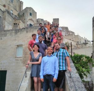 |
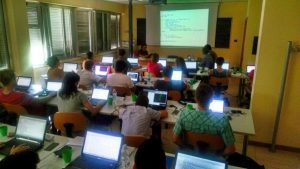
Intensive learning on geocomputing and scripting at University of Basilicata (left). Group photo at the last evening in the beautiful old town of Matera (right).